Dosiero:Caucasus-ethnic-1995.jpg

Grandeco de ĉi antaŭvido: 512 × 599 rastrumeroj. Aliaj distingivoj: 205 × 240 rastrumeroj | 410 × 480 rastrumeroj | 656 × 768 rastrumeroj | 875 × 1 024 rastrumeroj | 1 749 × 2 048 rastrumeroj | 2 606 × 3 051 rastrumeroj.
Fonta dosiero (2 606 × 3 051 rastrumeroj, dosiera grandeco: 2,46 MB, MIME-tipo: image/jpeg)

|
File:Caucasus-ethnic en.svg estas vektora versio de ĉi tiu bildo. Ĝi estu uzata anstataŭ la rastruma bildo.
File:Caucasus-ethnic-1995.jpg → File:Caucasus-ethnic en.svg
Pliajn informojn vidu ĉe Help:SVG. |
 |

|
Ĉi tiu dosiero estas anstataŭigita per File:Caucasus-ethnic-2004.jpg. Prefere uzu tiun alian dosieron.
|

|
Resumo
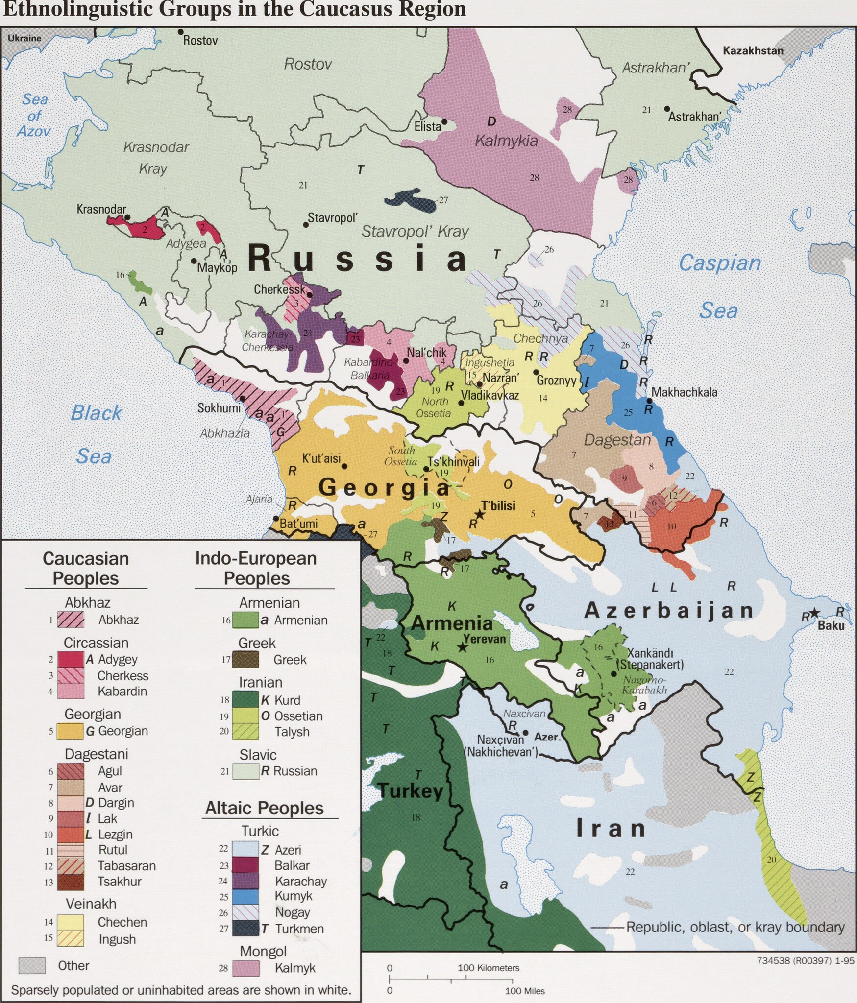
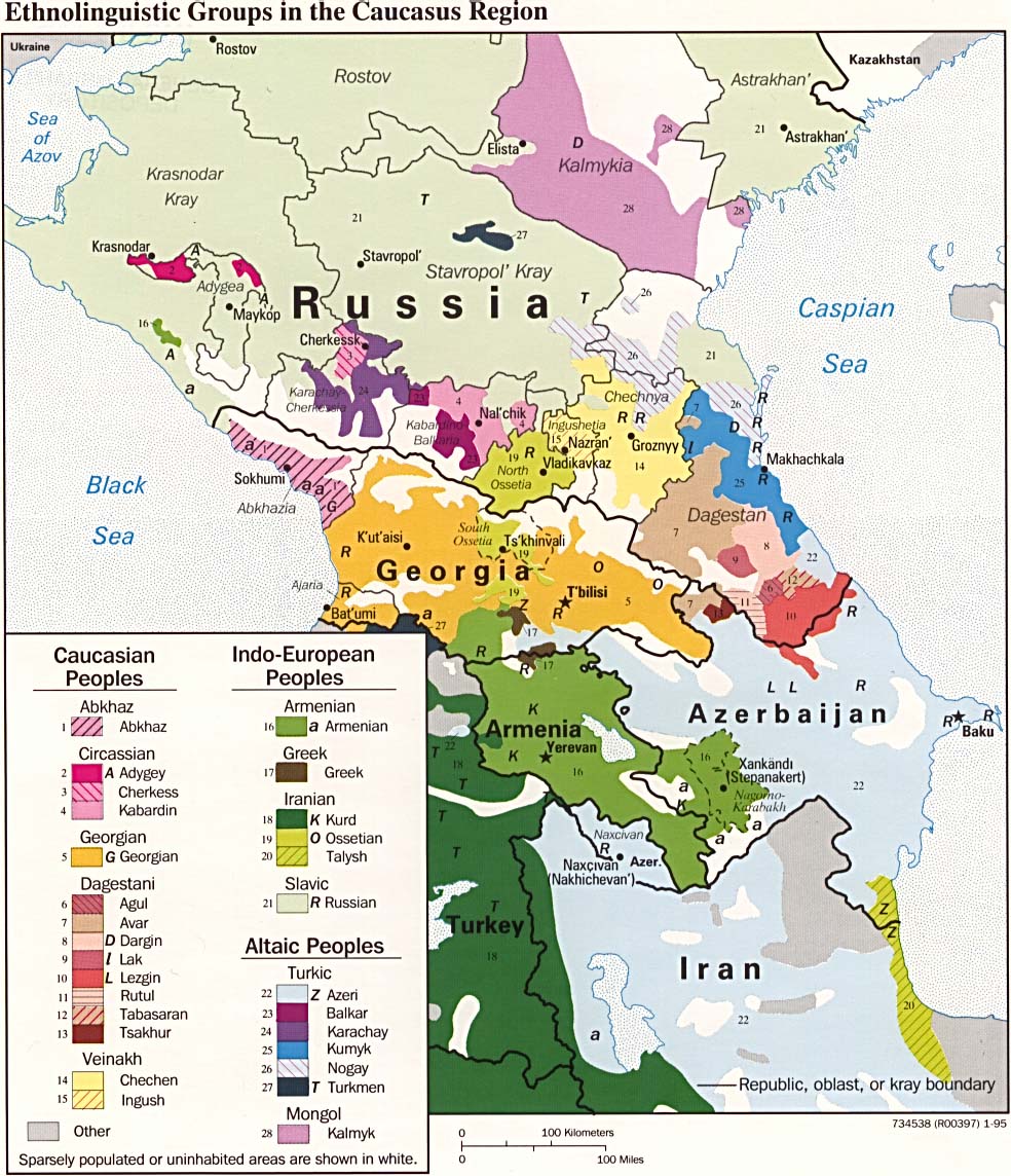
| Priskribo | CIA map on the ethnolinguistic groups in the Caucasus region. National borders are thick black, regional borders within one country in thin black, and disputed borders as dotted lines. |
| Dato | |
| Fonto |
https://www.loc.gov/item/95680196/ (permalink: https://lccn.loc.gov/95680196)
|
| Aŭtoro | U.S. Central Intelligence Agency |
| Permeso (Reuzo de la dosiero) |
Source states: "The following maps were produced by the U.S. Central Intelligence Agency, unless otherwise indicated." [1] |
| Ceteraj versioj |
[]
|


Permesiloj:
| This image is a work of a Central Intelligence Agency employee, taken or made as part of that person's official duties. As a Work of the United States Government, this image or media is in the public domain in the United States.
|

|
Dosiera historio
Klaku daton/tempon por vidi la dosieron kia ĝi aspektis tiam.
| Dato/tempo | Bildeto | Dimensioj | Uzanto | Komento | |
|---|---|---|---|---|---|
| nuna | 17:49, 29 mar. 2022 | | 2 606 × 3 051 (2,46 MB) | Cherkash | TIFF from the same source (https://www.loc.gov/item/95680196/) - first maximally cropped and then converted to JPG |
| 09:12, 22 mar. 2022 |  | 2 610 × 3 085 (2,41 MB) | Sette-quattro | Higher scan from the same source, from https://www.loc.gov/item/95680196/ | |
| 11:22, 4 jul. 2017 |  | 984 × 1 144 (269 KB) | Mikhail Ryazanov | Reverted to version as of 13:54, 29 November 2005 (UTC) | |
| 05:22, 4 jul. 2017 |  | 2 000 × 1 126 (1 024 KB) | Abdularehman | mast qalandar welfare association | |
| 05:21, 4 jul. 2017 |  | 2 000 × 1 126 (1 024 KB) | Abdularehman | mast qalandar welfare association | |
| 13:54, 29 nov. 2005 |  | 984 × 1 144 (269 KB) | Miaow Miaow | '''CIA map on the Ethno-Linguistic groups in the Caucasus region.''' National borders are thick black, regional borders within one country in thin black, and disputed borders as dotted lines. From http://en.wikipedia.org/wiki/Image:Caucasus-ethnic.jpg f |
Dosiera uzado
Neniu paĝo ligas al ĉi tiu dosiero.
Suma uzado de la dosiero
La jenaj aliaj vikioj utiligas ĉi tiun dosieron: